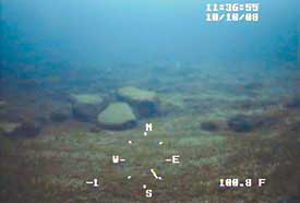
More than 100 feet deep in Lake Huron, on a wide, stony ridge that 9,000 years ago was a land bridge, U-M researchers have found the first archeological evidence of human activity preserved beneath the Great Lakes.

The researchers located what they believe to be structures used to hunt caribou and camps used by the early hunters of the period.
A paper about the findings is published in the June 8 issue of Proceedings of the National Academy of Sciences. Authors are John O’Shea, curator of Great Lakes Archaeology in the Museum of Anthropology and professor of anthropology, and Guy Meadows, director of the Marine Hydrodynamics Laboratories and a professor in the departments of Naval Architecture and Marine Engineering and Atmospheric, Oceanic and Space Sciences.
“This is the first time we’ve identified structures like these on the lake bottom,” O’Shea says. “Scientifically, it’s important because the entire ancient landscape has been preserved and has not been modified by farming, or modern development. That has implications for ecology, archaeology and environmental modeling.”
O’Shea and Meadows found features they believe to be hunting pits, camps, caribou drive lanes and stone piles used to attract the caribou to the drive lanes. Drive lanes are long rows of rocks used to channel caribou into ambushes. The 1,148-foot structure they believe is a drive lane closely resembles one on Victoria Island in the Canadian subarctic.
The hunting formations are on the 10-mile-wide Alpena-Amberley ridge that stretches more than 100 miles from Point Clark, Ontario, to Presque Isle, Mich. Between 10,000 and 7,500 years ago the ridge was a land bridge when water levels were much lower. Its surface is relatively unspoiled, unlike coastal areas where scientists believe other archeological sites exist. These coastal sites now would be deeply covered in sediment, so they’re often considered lost forever.
Scientists have hypothesized for some time that the ridge might hold signs of ancient occupations. But they didn’t know what signs to look for. O’Shea and Meadows zeroed in on hunting structures after considering the region’s climate at the time, which would have been similar to the subarctic. Subarctic hunters are known to utilize caribou drive lanes.
The U-M researchers then narrowed down where to look for these structures by modeling the lake ridge as it would have been when it was dry. They worked with Robert Reynolds, a computer science professor at Wayne State University, to reconstruct the ancient environment and then simulate caribou migrations across the corridor. Based on this, they picked three spots to examine.
O’Shea and Meadows used U-M’s new, cutting-edge survey vessel Blue Traveler, sonar equipment and underwater remote-operated vehicles with video cameras to survey these areas.
“Without any one of these advanced tools, this discovery would not have happened,” Meadows says.
Archaeologists trained as SCUBA divers will begin examining these areas this summer.
The Paleo-Indian and early Archaic periods are poorly known in the Great Lakes region because most sites are thought to have been lost beneath the lakes. Yet they also are times of major shifts in culture and the environment.
The Paleo-Indians were nomadic and pursued big game, O’Shea says. With the Archaic period, communities were more settled, with larger populations, a broad spectrum economy, and new long distance trade and ceremonial connections.
“Without the archeological sites from this intermediate time period, you can’t tell how they got from point A to point B, or Paleo-Indian to Archaic,” O’Shea says. “This is why the discovery of sites preserved beneath the lakes is so significant.”
Perhaps more exciting than the hunting structures themselves is the hope they bring that intact settlements are preserved on the lake bottom. These settlements could contain organic artifacts that deteriorate in drier, acidic soils on land.

